

Evaluación de la vulnerabilidad sísmica de la ciudad de Cartago en los Distritos Oriental y Occidental, Costa Rica
Date
2016Metadata
Show full item recordAbstract
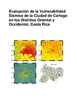
Historically the city of Cartago has been greatly affected, even it has been destroyed on two occasions product of earthquakes, which they have killed hundreds of people. The first of these occurred in 1841, while the second occurred in 1910. Both events associated with the seismic fault of Agua Caliente. Because of the historical seismicity than suffers, it is determined that the failure of Agua Caliente is the main source of threat to the city of Cartago. To assess the seismic vulnerability of the buildings in the area, before it was necessary to conduct a study of seismic hazard for the three seismic scenarios were presented using the method deterministic, describing the potential for seismic fault. Seismic hazard maps were made in QGIS (2015), using motion intensity parameter acceleration and attenuation equation as proposed by Climent et. (1994). For stage 1 of peak accelerations they were obtained 5,29 m/s2, For stage 2 the 3,35 m/s2 and also for the stage 3 the 2,22 m/s2. Intensities were instrumental VIII, VII and VI respectively for each scenario. A visual inspection was conducted to classify buildings as one of the types of report (ENR-CAPRA, T2-5). Seven types in total are obtained, using QGIS (2015) seismic vulnerability maps are made by evaluating seismic vulnerability functions defined by the report (ENR-CAPRA, T2-5). Finally seismic vulnerability maps are obtained in terms of % damage to each building.
Description
Proyecto de Graduación (Licenciatura en Ingeniería en Construcción) Instituto Tecnológico de Costa Rica, Escuela de Ingeniería en Construcción, 2016.