

Plan maestro y diseño de infraestructura para la zona de Wafer y Chatam del Parque Nacional Isla del Coco
Abstract
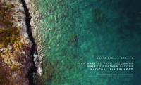
Cocos Island is the furthest National Park from Costa Rican territory, that is also a conservation center of nature, important wildlife refuge, Natural Heritage of Humanity, object of multiple investigations focused on the green agenda and nature protection. However, it doesn’t have studies about the territory planning to guide the construction of the basic infrastructure needed to protect and care the resources.
This investigation is focused in te resolution of planning lack and site design in the special use zone, that according to the Management Plan of Cocos Island National Park, is the allowed área to the construction of infrastructure.
Knowing this necessity, the Master Plan, and Infrastructure Design for Wafer and Chatham zones of Cocos Island, National Park is stablished, proponing based on a diagnosis the site design, analyzing all the variables immersed, such as physical, morphological, functional and patrimonial characteristics, with the objective of giving to the administrative department a tool that enables them to organize the bays, and establish priorities about the different problems to solve, being consistent with the park’s cultural value.
A planning proposal is designed, conceived from a sustainable development visión, in harmony and mimesis with the nature, coordinated with the Management Plan objectives, the cultural heritage and the protection of resources as a natural paradise.
The priority is to solve the functional problems which affect or hinder the preservation and protection labors, carried out by park rangers, proponing also in a preliminary project level, a solution o an administrative building, also solving in modules the need of mínimum spaces for tourists.
Description
Proyecto de graduación (Licenciatura en Arquitectura y Urbanismo) Instituto
Tecnológico de Costa Rica, 2017